Lompat ke isi

Borkas:Washington, D.C. locator map.svg

Konten halaman tidak didukung dalam bahasa lain.
Tingon Wikipedia

Berkas asli(Berkas SVG, nominall 750 × 550 piksel, ukuran berkas: 160 KB)

File on tingon Wikimedia Commons dot bisa ipake ni proyek lain. Deskripsi i alaman deskripsi file i sadun ipatidaon naitoruon.

Deskripsi
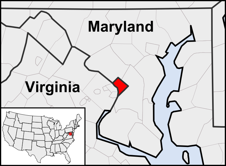
English: This is a map of the location of the District of Columbia showing the borders of states and counties around it.
Tanggal (UTC)
Sumber
Panulis
Versi lainnya

Derivative works of this file:  United States geographical collation.svg All the below are of the states (and DC) only.
Blank US map.svg Map of states
Labelled US map.svg Map with state labels
USA_blank.svg Image with Hawaii and Alaska in full size
Original blank map of USA and Canada, That image with labels
Original with Hawaii at the natural distance, That original map with labels

File:DC locator map with state names w usmap.png and File:DC locator map with state names.jpg


Ini merupakan gambar hasil penyuntingan yang berarti bahwa gambar tersebut telah diubah secara digital dari versi asli. Perubahan: Cropping to area around District of Columbia. Versi asli dapat dilihat di sini: Blank USA, w territories.svg. Perubahan dibuat oleh Patrickneil.

w:id:Creative Commons
atribusi marbagi sarupo
Berkas on ilisension i toru Creative Commons Attribution-Share Alike 3.0 Unported lisensi.
Amu saroa:
  • mambagion – tu manyalin, mandistribusion dot mangirimkon kario
  • manguba – tu manyasueon karejo
Itoru kondisi ima:
  • atribusi – Amu angkon mangalehen kreadit na sasuai, mambaen tautan i anso marlisensi, dohot patidaonkon bahaso adong parubahan. Ho bisa mambaen na dohot cara snga sonjia pe carana na memang masuk i akal ma, taitong inda dohot cara sanga sonjia pe na patidaon bahasona na mangalehen lisensi mandukung ho sangape mambaen ho.
  • marbagi sarupo – Molo Amu manguba, sanga mambangun i ginjang karejo on, Amu bisa mandistribusion kario na ihasilkon umna i toru ina sarupo sanga sarupo dohot lisensi on ima na asli.

Log pengunggahan asli

This image is a derivative work of the following images:

  • File:USA_Counties.svg licensed with PD-USGov-DOC-Census
    • 2007-12-23T15:47:48Z Lokal Profil 555x352 (2124572 Bytes) Fixed state borders and fixed the two parts of Fulton County (Kentucky)
    • 2007-12-10T02:20:23Z Lokal Profil 555x352 (2136501 Bytes) Graphical and code cleanup
    • 2007-12-10T01:15:05Z Lokal Profil 792x612 (2135690 Bytes) First stab at a code cleanup
    • 2006-08-29T00:14:37Z Petr Dlouhý 792x612 (2844548 Bytes) Original file: [[:en:Image:USA CountiesSVG.zip]] This [[ZIP (file format)|ZIP]] file contains an [[SVG]] map of the [[United States]] showing the borders of states and counties in high detail. It was derived from [http://ww
  • File:Blank_USA,_w_territories.svg licensed with Cc-by-sa-3.0-migrated, GFDL
    • 2009-01-30T01:59:59Z Hoshie 959x593 (98189 Bytes) Reverted to version as of 23:58, 14 January 2009 - rv myself; DC can be seen clearly.
    • 2009-01-18T23:34:42Z Hoshie 959x593 (102341 Bytes) Put DC in an inset; fixed Tutuila (American Samoa)
    • 2009-01-14T23:58:05Z Lokal Profil 959x593 (98189 Bytes) Code cleanup and removed stroke from Guam and American Samoa
    • 2009-01-13T05:19:51Z Hoshie 959x593 (101361 Bytes) re did Guam and added American Samoa
    • 2007-12-02T16:08:45Z Lokal Profil 959x593 (88960 Bytes) {{Information |Description=A blank map of the United States including Puerto Rico, Guam, the United States Virgin Islands, and the Northern Mariana Islands. |Source=This version was made by [[:User:Lokal_Profil|Lokal_Profil]]

Uploaded with derivativeFX

Captions

Add a one-line explanation of what this file represents

Items portrayed in this file

menggambarkan Indonesia

status hak cipta Indonesia

berhak cipta Indonesia

sejak Indonesia

12 Agustus 2010

Sejarah berkas

Klik tanggal / woktu giot maligi file songon na na i woktu i.

(nNabaru | naonok) Sise (nabaru 10 | ) (10 | 20 | 50 | 100 | 250 | 500)
Tangagal/WoktuGambarUkuranPamakeKomentar
saonnari23 Juli 2011 10.23Gambar tu versi par 23 Juli 2011 10.23750 × 550 (160 KB)PatrickneilReverted to version as of 03:04, 23 July 2011
23 Juli 2011 10.21Gambar tu versi par 23 Juli 2011 10.21750 × 550 (161 KB)PatrickneilReverted to version as of 03:14, 23 July 2011
23 Juli 2011 10.20Gambar tu versi par 23 Juli 2011 10.20750 × 550 (161 KB)Patrickneilframe
23 Juli 2011 10.14Gambar tu versi par 23 Juli 2011 10.14750 × 550 (161 KB)Patrickneilthicker frame
23 Juli 2011 10.04Gambar tu versi par 23 Juli 2011 10.04750 × 550 (160 KB)Patrickneilstraightening Maryland and Delaware borders
15 Agustus 2010 09.09Gambar tu versi par 15 Agustus 2010 09.09750 × 550 (202 KB)PatrickneilDelaware River again
15 Agustus 2010 08.51Gambar tu versi par 15 Agustus 2010 08.51750 × 550 (274 KB)PatrickneilDelaware River border
15 Agustus 2010 08.42Gambar tu versi par 15 Agustus 2010 08.42750 × 550 (273 KB)Patrickneilforgot border on Smith Island
15 Agustus 2010 08.34Gambar tu versi par 15 Agustus 2010 08.34750 × 550 (273 KB)Patrickneilcounty borders below state
15 Agustus 2010 08.32Gambar tu versi par 15 Agustus 2010 08.32750 × 550 (274 KB)Patrickneilchanges by request
(nNabaru | naonok) Sise (nabaru 10 | ) (10 | 20 | 50 | 100 | 250 | 500)

Onma page links tu berkas on:

Pamakean berkas sude

Wiki lain namamake berkas on:

Sise pamakean global ni berkas on.